Poking a complex system – Will the end of La Niña mean record temperature rise?
‘La Niña has ended’ according to the World Meteorological Organization (WMO), who made the declaration last week. La Niña gave way in early April, and conditions in the equatorial Pacific Ocean have now returned to ‘neutral’. But what does that actually mean – both in a literal sense, and in terms of the effect it might have on the world’s average temperature?
La Niña is a recurring state of the atmosphere and oceans that forms part of a cycle in large-scale climate and ocean patterns in the equatorial Pacific Ocean, called the El Niño Southern Oscillation ( ENSO).
About half of the time the Pacific Ocean experiences what are called ‘ENSO-neutral’ conditions. This means that sea surface temperature and the very predictable trade winds that blow east to west over the equatorial Pacific Ocean (from South America towards Indonesia) are similar to their long-term averages.
The rest of the time conditions in the equatorial Pacific swing between the two extremes of the ENSO; La Ni̱a and El Ni̱o. During La Ni̱a, colder seawater in the eastern equatorial Pacific spreads along the equator, and the trade winds become stronger. In contrast, El Ni̱o involves the reverse Рwarmer seawater spreading along the equator from the eastern Pacific, and weaker trade winds than usual.
Both El Niño and La Niña alter global atmospheric circulation, and disrupt weather and climate patterns in many parts of the world.
Scientists have identified that ENSO swings between El Ni̱o and La Ni̱a every 3 Р7 years, but the reasons for the swing are not yet fully understood.
This video shows how ENSO varied between 2008 and 2012 as measured by satellites. El Niño is identified by red (warmer seawater), La Niña by a blue (cooler seawater), in the eastern Pacific Ocean.
Source: NASA Earth Obsevatory
ENSO outlook for 2012
Now that the equatorial Pacific has shifted away from La Niña and back towards neutral conditions, what effects will this have on the climate in 2012?
The WMO suggests that during the rest of 2012, neutral and El Niño conditions are equally likely to occur. The Australian Bureau of Meteorology, on the other hand, says that its climate models predict a return to El Niño conditions during 2012:
“All seven models surveyed indicate conditions are likely to approach, or possibly exceed, El Niño thresholds during the second half of the year. This suggests an enhanced risk of El Niño conditions developing during 2012.”
Both organisations agree that neutral conditions are likely to persist over the next couple of months, and that a return to La Niña is unlikely during 2012.
The effect on global temperatures
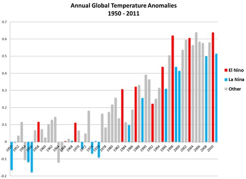
As you can see in the image below, ENSO is one of the big processes producing natural variability in the global average temperature.
La Niña – which has just ended and we’ve had for the last few years – reduces the global average surface temperature. El Niño returns makes the global surface temperature warmer than average, as it redistributes heat from the ocean to the atmosphere.
Image - ENSO and global average temp (note)
Source: NOAA
Last year there was a fairly strong ‘double-dip’ La Niña, which NASA scientist James Hansen suggests lowered the global average temperature to below what it might have been in an El Niño or ENSO-neutral year. So, all other things (e.g. aerosols, solar activity) being equal, it seems reasonable to anticipate a warmer global average temperature for 2012 if ENSO-neutral conditions persist, particularly if a shift to El Niño conditions occurs later in the year.
As Hansen puts it:
“It won’t take a very strong El Niño to push temperatures above 2010.”
But it might not be that simple, because other researchers have different ideas. Kyle Swanson and Anastasios Tsonis from the University of Wisconsin-Milwaukee believe it could be quite some time before we see another record-breaking year.
In a 2009 paper they suggest that the climate system shifts between colder and warmer regimes, and there are also shifts in how ENSO varies. For example, in the early 1940s, the global warming trend sped up, accompanied by La Niña events becoming less frequent.
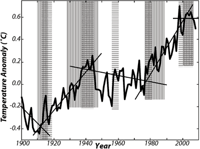
Such climate shifts, they suggest, are accompanied by temporary slowdowns or speeding up of the long-term warming trend. Over the past century, they may have occurred around 1910, 1940, 1976 and 2001; shown in the graph below.
Image - Swanson and Tsonis temp with synchronisation (note)
Global average surface temperature over the 20th century (HadCRUT3), with approximate breaks in temperature indicated. Source: Swanson and Tsonis (2009).
Swanson and Tsonis suggest that the warming trend before the very strong El Niño of 1997-1998 is the “true [greenhouse gas] forced warming signal” and that:
“[T]he climate system effectively overshot this signal in response to the 1997/98 El Niño. This overshoot is in the process of radiatively dissipating, and the climate will return to its earlier defined, greenhouse gas-forced warming signal. If this hypothesis is correct, the era of consistent record-breaking global mean temperatures will not resume until roughly 2020.”
This conclusion, they say:
“[H]ighlights the fact that humanity is poking a complex, nonlinear system with [greenhouse gas] forcing – and that there are no guarantees to how the climate may respond.”
It’s also worth pointing out that predicting how ENSO will vary beyond a couple of months into the future is tricky, and the jury is still out on how, if at all, man-made global warming might change the ENSO patterns.
This is all quite a complicated picture in the end, reflecting the process of developing understanding in this area of science. And it all means that making simple predictions about what effect El Niño/La Niña will have on temperature this year is simply not straightforward.