Guest post: The critical role of ‘grounding zones’ in the retreat of Earth’s ice sheets
The vast ice sheets that cover Greenland and Antarctica have the potential to trigger catastrophic sea level rise as the climate warms.
But the ice-sheet models that scientists use to project future changes underestimate how fast sea levels are rising now and how much they have risen in the past.
This suggests the models are missing important processes driving ice-sheet retreat.
New research suggests that melting at grounding zones – where the ice transitions from sitting on land to floating on water – could be the missing piece of the puzzle.
And it is potentially a big piece. For example, when one study on the Thwaites glacier in west Antarctica included these processes, its projections of ice-sheet loss more than doubled.
In this guest post, we unpack the latest research on grounding-zone mechanisms and why they suggest that current global projections of sea level rise may be substantially underestimated.
§ Ice sheets are shrinking faster than models project
Scientists use ice-sheet models to project how fast – and by how much – the Earth’s ice sheets will shrink as global temperatures rise.
These models, developed by scientists at universities and national research institutes, represent physical real-world processes using sets of equations. By solving these equations, scientists gain understanding how the physical system will respond to different scenarios. There are around 20 ice sheet models in use around the world today.
The models capture what we know about how ice sheets flow and deform. Projections using these models suggest that ice sheets will contribute 10s of centimetres to sea level rise by the end of the century.
However, it increasingly looks like these models underestimate the true sensitivity of ice sheets to climate change.
First, we can look at sea level rise from ice sheets over the past 20-25 years. Over this period, we have detailed satellite observations to compare to model predictions.
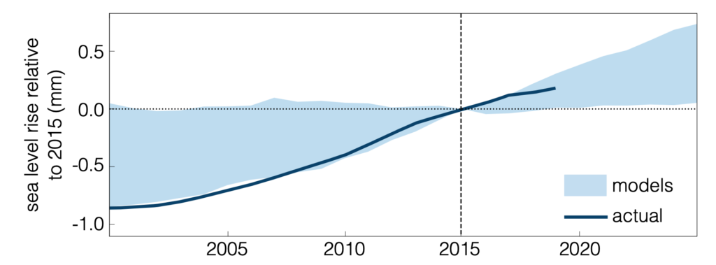
The figure below shows the spread in projections from models (blue shading) for Greenland’s contribution to sea level rise compared to the satellite data (blue line). This spread is generated by a range of factors, such as how different models describe ice flow, how fine of a resolution they use to represent the real system and the initial state used for model runs. Sea levels are presented relative to 2015, as this was chosen as a benchmark year.
It is clear that the majority of models underestimated the rate of Greenland melt.
Next, we can consider whether models have succeeded in reproducing ice sheet loss from historical warm periods.
For example, proxy records, such as reconstructions of previous shorelines, indicate that during the Pliocene (5.3-2.6m years ago) sea levels were between six and 40 metres higher than today.
This extreme sea level rise would have required a substantial contribution from the world’s ice sheets. However, models are largely unable to reproduce these values, with almost all failing to even attain lower bounds.
Finally, from a different standpoint, we can ask how much climate forcing is required to reproduce current ice sheet retreat rates. Models of the west Antarctic ice sheet typically require ice shelves, which restrain the flow of grounded ice, to be melted very rapidly in order to reproduce current rates. However, recent observations of melting in these regions suggest it is in fact far smaller than models require.
Together, this evidence suggests that ice-sheet models are not entirely capturing what is going on: they should be more sensitive to changes in the climate than they currently are. Two recent papers have suggested that what happens in so-called “grounding zones” could be the missing piece of this puzzle.
§ Grounding zones
Ice sheets are not static; they spread out like a very thick liquid. The majority of ice in the world’s ice sheets sits on top of land, above sea level. As the ice spreads out and thins, it begins to float, transitioning into a floating ice shelf.
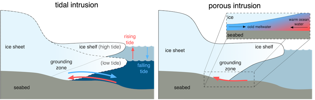
The boundary between ice on land and floating ice shelves – shown in the figure below – is known as the “grounding zone”.
The classical picture of grounding zones is as distinct boundaries between floating and grounded ice. It was previously thought that they migrate on annual-to-decadal timescales as ice sheets retreat and advance, and that little melting took place there.
Recently, however, a different picture has emerged, where grounding zones are actually highly dynamic regions.
In particular, two independent mechanisms – called “tidal intrusion” and “porous intrusion” – are thought to be taking place in grounding zones.
Both of these mechanisms are thought to allow relatively warm ocean water to rush under ice sheets, enabling vigorous melting to take place there.
§ Tidal intrusion
Antarctica has one of the largest tidal ranges in the world, with sea levels fluctuating by up to seven metres each day.
As the tide rises, water pressure under ice shelves increases, lifting the ice and creating a new cavity in the grounding zone. As a result, this newly formed cavity, which can be up to 15km long, is rapidly filled with ocean water.
When the tide falls, the reverse happens: the ice settles back down and water flushes out of the cavity. This cyclic process – named “tidal intrusion” – occurs up to twice per day, driving rapid flows of warm ocean water into and out of the grounding zone, where it can melt the ice from below.
The tidal opening and closing of grounding zone cavities can be observed using surface elevation and radar measurements from satellites. However, these observations – particularly in fast-changing regions – have typically been limited by how frequently the satellites pass over the same spot, which varies between weeks and months.
Recent research, published last month, has used a unique set of sub-daily satellite observations from the ICEYE constellation to show that tidal intrusion is widespread beneath Thwaites glacier.
This research indicates that warm water is able to intrude up to 6km beneath the Thwaites ice shelf during each high tide, where it could accelerate ice melt from below.
Thwaites – nicknamed the “doomsday glacier” – holds enough ice to raise global sea levels by up to 65cm and has long concerned scientists because of its rapid present retreat, potential for runaway ice loss and possibly important role as a keystone in the west Antarctic ice sheet.
This new research suggests that Thwaites may be even more vulnerable than previously thought.
§ Porous intrusion
Beneath ice sheets, there are networks of channels and tunnels, as well as porous sediments, through which meltwater from the bottom of ice sheets flows.
In grounding zones, this cold, fresh meltwater meets relatively warm, salty ocean water. The ocean water is denser, allowing it to intrude beneath the meltwater and into the grounding zone. This process is called “porous intrusion”.
Recent modelling has suggested that ocean water can intrude kilometres beneath ice sheets via this mechanism.
However, previous research has not considered how the geometry of these regions change in response to melting. In our new study, published in Nature Geoscience, we show that, when this effect is considered, the porous intrusion mechanism can be far more powerful.
In particular, we show that these systems display a tipping-point like behaviour, in which a small change in ocean temperatures can lead to a dramatic change in the distance that warm water is able to intrude through grounding zones.
We also show that the porous intrusion mechanism is not only applicable to ice shelves exposed to warm water or with high melt rates at a glacier’s base, such as Thwaites, but can also influence cold water ice shelves.
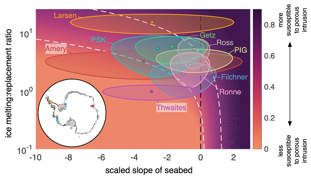
The susceptibility of a glacier to porous intrusion is linked to the slope of the seabed and how quickly melted ice is replaced. This is illustrated in the figure below; glaciers in the purple-shaded area are the most susceptible.
In fact, Thwaites appears to be relatively unsusceptible to porous intrusion – despite being highly vulnerable to tidal intrusion – because it flows very rapidly and ice is replaced very quickly.
Other ice shelves, such as the Ross and Ronne ice shelves, which sit in relatively cold water may, surprisingly, be amongst the most susceptible ice shelves.
§ Are grounding zones the missing piece?
The majority of ice-sheet models still represent grounding zones as a distinct transition between grounded and floating ice, with no melting there from either tidal or porous intrusion.
The only models able to attain anything resembling sea level rise values during past warm periods have included a grounding-zone melting mechanism or a similar mechanism that boosts their sensitivity to climate change.
These same models have also received much attention for their pessimistic future sea level rise projections. Capturing the past requires an increased sensitivity to climatic change, meaning that they predict much higher sea level rise in future.
So, grounding zone intrusion and melting might be the missing piece to reconcile observed and modelled sea level rise.
While scientists have yet to run model simulations with grounding-zone melting included for the whole of Antarctica, studies focusing on specific regions of the continent’s ice sheets project up to twice as much sea level rise.
Current global projections of sea level rise also do not include grounding-zone melting. This means that these projections – including those that inform the reports of the Intergovernmental Panel on Climate Change (IPCC) – may be substantial underestimates.
Ice-sheet models have “known unknowns” – things we know that we do not know perfectly, but can account for imperfect knowledge of. However, they also have “unknown unknowns” – things that we do not even know are happening and therefore cannot quantify the full effects of.
Although grounding-zone melting might result in higher sea level than we expected, at least we now know that it is happening and can begin to incorporate it into our models. The devil we know is better than the devil we don’t.